


BLACKKITE-I |
MADE FOR THE SKIES
IR WIDE-AREA SURVEILLANCE SYSTEM FOR UAS |
Observe From Above
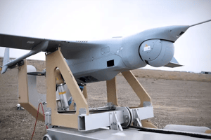
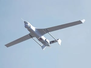
BlackKite-I is an infrared (IR) wide-area motion imagery (WAMI) sensor configured specifically for the payload bay of the Insitu Integrator, a Group 3 unmanned aircraft system (UAS). Like larger day/night WAMI systems, BlackKite-I monitors a city-sized area in near real-time, detecting and tracking all significant movers in the scene, while also recording events for later analysis.
BlackKite-I employs our multi-modal edge processor (MMEP), a high-performance processor that converts gigabytes of data into geo-tagged imagery—eight hours of which can be stored locally, while the sensor is still airborne. Operators on the ground access live and recorded IR imagery from the WAMI system, in real time.
Features
- Ultra-lightweight – less than 28 lbs
- Coverage of an area up to twelve square kilometers
- Resolution optimized to track vehicles and detect moving dismounts
- High-performance, real-time onboard multi-modal edge processor (MMEP)
- Onboard storage of up to eleven hours of mission data
- Transmission of multiple unique streaming video windows to operators on the ground
- Imagery transmitted to handheld devices
- User-defined “watchboxes” provide automated detection alerts
Built for Every Mission
- Force protection
- Tactical-level persistent surveillance
- Route reconnaissance and overwatch
- Border security
- Police aerial patrol
- Suspect tracking
- Data-driven policing
- Monitoring wildfires and suppression progress
SPECIFICATIONS |
Surveillance at Scale
The BlackKite-I IR WAMI system provides constant streams of geo-located real-time and forensic imagery for multiple users, all from the payload bay of the Insitu Integrator. Employing a midwave IR sensor, the BlackKite-I can monitor a citysized area both day and night.
PAYLOAD, WEIGHT & POWER
Bay Size
41 in L x 12 in W x 8 in H (105 cm x 31 cm x 21 cm)
Bay Weight
< 28 lbs (13 kg)
Bay Power
< 300 W max, < 250 W nominal
Processing
Processing embedded in payload
COVERAGE & PERFORMANCE
Operational Altitude
5,000 ft – 12,000 ft (1,500 m – 4,000 m) AGL
Areas of Coverage
2.2 sq km at 5,000 ft (1,500 m) AGL, 12.0 sq km at 12,000 ft (4,000 m) AGL
GSDS
< 0.25 m at 5,000 ft (1,500 m) AGL, 0.6 m at 12,000 ft (4,000 m) AGL
Imaging Modality
3 Mpx InSb MWIR 10 μm px realizing 54 Mpx composite image
Refresh Rate
1 Hz
Cross-Cueing
Yes
Viewer Windows
Up to 10 unique streaming video windows
Onboard Archive Length
~ 5 hrs (4 TB drive), ~ 11 hrs (8 TB drive)
GCS/SCS Archive Length
160 hrs, expandable
Imagery Transmission
Onboard, control centers, mobile devices
Datalink
Internal datalink, providing a fully integrated single LRU
Internal Processing
Compact embedded processing includes north-up rendering, real-time and DVR-like streaming, and full-mission storage
CUSTOMIZABLE GROUND/SENSOR CONTROL STATION
Sensor Control & Exploitation
Ground-based (transportable or fixed) and/or aircraft-based
Components
Control server, client, archive server, storage array, UPS, accessories
GCS/SCS Size
8 U, 30 in rack depth
GCS/SCS Weight
< 250 lbs (115 kg) / < 400 lbs (180 kg) with cases
GCS/SCS Power
< 1 KW, 100% duty cycle
GET IN TOUCH |
Ready to Talk Perception & Sensing?
Get in touch with one of our experts to get more details and availability about our Perception & Sensing solutions.


